Technical informations
-
Distance 40.6km
-
Difficulty Very difficult
-
Type of itinerary Loop
-
Ascent 895m
-
Negative gradient n/c
-
Daily duration 04h15
-
Itinéraire balisé BALISE
-
Nature du terrain Ground
-
Altitude moyenne n/c
-
Altitude maximum n/c
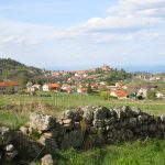
A mountain bike rides guide covering the Pays de Saint Bonnet le Château, available in the tourist office of Saint Bonnet le Château and Usson en Forez.
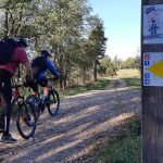
Description
4 departures are suggest, numbered from 1 to 4. Circuits are marked in yellow with the mention "Pays de Saint Bonnet le Château" in green. Each number indicates the village of departure and a letter indicates the difficulty level of the path.The riding difficulty increases from "A" to "D". Those circuits are made up of a basic (A) which gives access to the B, C and D laps in order to lenghten the ride as you wish.
Equipements
- Cycling sports
- Mountain biking itinerary
Type of clientele
- Level black - very hard
- For experts / practiced