

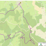
From downtown Thiers, take the D2089 towards Chabreloche. At Pont-de-Celles, turn right towards Celles-sur-Durolle. Park near the Celles town hall.
Technical informations
-
Distance 15.5km
-
Type of itinerary Loop
-
Ascent 555m
-
Negative gradient n/c
-
Daily duration 04:30
-
Itinéraire balisé BALISE
-
Précision balisage Green
-
Altitude moyenne n/c
-
Altitude maximum 876m
From Celles-sur-Durlle, a place of pagan worship since ancient times (water source), this wild, wooded circuit offers beautiful panoramic views of the Chaîne des Puys and the Château de Vaulx.
Good deals
- Tips : View of the Chaîne des Puys.
-
Guidebook with maps/step-by-step : 1/ From the Celles-sur-Durle town hall parking lot, take the tarmac road on the left. Take the first road on the right and continue along the road on the left. At the T-junction, take the grassy path downhill opposite. At a cross, continue on the same path (viewpoint over the village of Saint-Rémy-sur-Durolle). At the fork in the road, continue along the path. At the crossroads, follow the road opposite. 20 m further on, take the track on the left. At the crossroads, go straight on to Ostancie. In the hamlet, turn right up the road.
2/ 20 m further on, cross the D7 and go straight on. After 20 m, at the crossroads, turn left. At the house, turn right. After 20 m, go left. At the T-junction, turn left and climb up to La Vacherie. At the entrance to the hamlet, continue slightly right on the same road. Follow this road (viewpoint over the Chaîne des Puys). After 500 m, leave the road and take a path to the left. Pass a ruined house and continue straight ahead. Go around the two ponds to reach a wider path.
2. turn right, then take the first track on the left towards Château de Vaulx. Go straight on until you reach the road you're on to rejoin the D7. Take the road opposite towards Rochemulet. Leave this road to take the second carriageway on the left, after a bend, to climb to Puy d'Oscot. Follow the main road to a logging area.
4/ Continue on the right-hand track. At the crow's-foot, take the track on the left. At the T junction, take the left-hand track. At the next crossroads, take the track opposite downhill. 50 m before the tarmac road, take the left-hand track to reach the crossroads at La Croix des Olmes.
5/ At the crossroads, turn right onto the D 321; 10 m further on, turn left. Stay on the main track until you reach the road. Follow it to the right. Cross the stream and, 10 m further on, take the track opposite. Follow the road straight ahead, skirting the sports complex on the right until you reach the D7. Cross it and head for the village center. Continue straight ahead to reach the Celles-sur-Durolle town hall parking lot.
Proposed and managed by the Conseil départemental du Puy-de-Dôme - PDIPR.
Labels
- Listed PDIPR
Complementary welcome
For your own safety, always take a bottle of water, a hat, warm clothing and footwear suitable for walking.
Depending on weather conditions, certain itineraries are not recommended in bad weather (fog) or are not practicable, or even forbidden, during the winter season.
Some sites are fragile, so stay on the marked trails. Avoid picking wild flowers and disturbing wildlife. Pick up your garbage.
Animals are not allowed on some routes.
Equipements
- Pedestrian sports
- Hiking itinerary
services
- Pets welcome